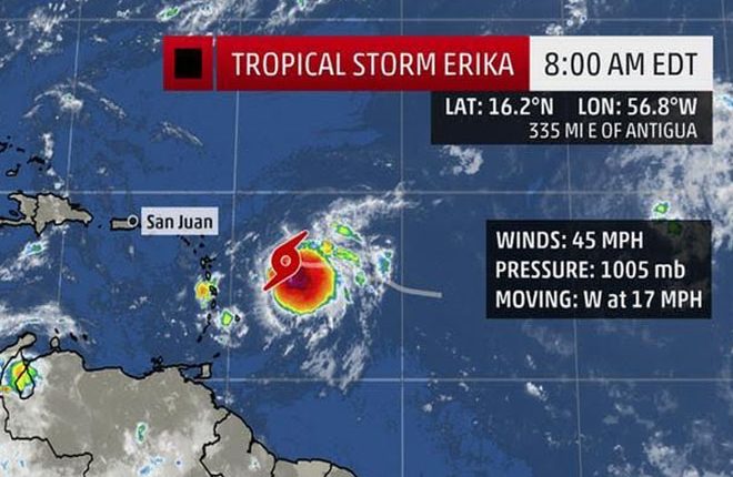
TRACKING ERIKA…….8AM REPORT
TROPICAL STORM ERIKA INTERMEDIATE ADVISORY NUMBER 6A
NWS NATIONAL HURRICANE CENTER MIAMI FL
800 AM AST WED AUG 26 2015
HURRICANE HUNTER AIRCRAFT FINDS ERIKA SLIGHTLY STRONGER
SUMMARY OF 800 AM AST…1200 UTC…INFORMATION
———————————————-
LOCATION…16.2N 56.8W
ABOUT 335 MI…540 KM E OF ANTIGUA AND 397 MI / 640 KM ESE OF ST. KITTS & NEVIS.
MAXIMUM SUSTAINED WINDS…45 MPH…75 KM/H
PRESENT MOVEMENT…W OR 280 DEGREES AT 17 MPH…28 KM/H
MINIMUM CENTRAL PRESSURE…1005 MB…29.68 INCHES
WATCHES AND WARNINGS
——————–
CHANGES WITH THIS ADVISORY:
None.
SUMMARY OF WATCHES AND WARNINGS IN EFFECT:
A Tropical Storm Warning is in effect for;
* Anguilla
* Saba and St. Eustatius
* St. Maarten
* Montserrat
* Antigua and Barbuda
* St. Kitts and Nevis
* Puerto Rico
* Vieques
* Culebra
* U.S. Virgin Islands
* British Virgin Islands
A Tropical Storm Watch is in effect for;
* Guadeloupe
* St. Martin
* St. Barthelemy
A Tropical Storm Warning means that tropical storm conditions are expected somewhere within the warning area, generally within 36 hours.
A Tropical Storm Watch means that tropical storm conditions are possible within the watch area, generally within 48 hours.
For storm information specific to your area in the United States, including possible inland watches and warnings, please monitor products issued by your local National Weather Service forecast office. For storm information specific to your area outside the United States, please monitor products issued by your national meteorological service.
DISCUSSION AND 48-HOUR OUTLOOK
——————————
At 800 AM AST (1200 UTC), the center of Tropical Storm Erika was located near latitude 16.2 North, longitude 56.8 West. Erika is moving toward the west near 17 mph (28 km/h), and a west to west-northwestward motion is expected over the next 48 hours. On the forecast track, the center of Erika will move near or over portions of the Leeward Islands tonight and move near the Virgin Islands and Puerto Rico on Thursday.
Data from an Air Force Reserve Hurricane Hunter aircraft indicate that the maximum sustained winds have increased to near 45 mph (75 km/h) with higher gusts. Some slow strengthening is forecast during the next 48 hours.
Tropical storm force winds extend outward up to 105 miles (165 km) primarily to the east of the center.
The latest minimum central pressure reported by an Air Force Reserve Hurricane Hunter aircraft is 1005 mb (29.68 inches).
HAZARDS AFFECTING LAND
WIND: Tropical storm conditions are expected to first reach the warning area in the Leeward Islands tonight, and reach the Virgin Islands and Puerto Rico on Thursday. Tropical storm conditions are possible in the watch area tonight and early Thursday.
RAINFALL: Erika is expected to produce total rain accumulations of 2 to 4 inches with maximum amounts of 8 inches across portions of the Leeward Islands, the Virgin Islands, and Puerto Rico through Friday morning.
Next Advisory will be at 11am.

