Tacking Erika…..2pm Report
TROPICAL STORM ERIKA INTERMEDIATE ADVISORY NUMBER 7A
NWS NATIONAL HURRICANE CENTER MIAMI FL AL052015
200 PM AST WED AUG 26 2015
…ERIKA CONTINUES WESTWARD…
…NOAA HURRICANE HUNTER AIRCRAFT ON ITS WAY TO INVESTIGATE
THE STORM…
SUMMARY OF 200 PM AST…1800 UTC…INFORMATION
———————————————-
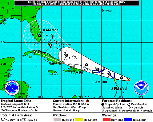
LOCATION…16.3N 58.2W
ABOUT 300MI.490KM ESE OF ST. KITTS AND NEVIS (CORRECTED DISTANCE)
ABOUT 245 MI…395 KM ESE OF ANTIGUA
MAXIMUM SUSTAINED WINDS…45 MPH…75 KM/H
PRESENT MOVEMENT…W OR 280 DEGREES AT 17 MPH…28 KM/H
MINIMUM CENTRAL PRESSURE…1005 MB…29.68 INCHES
WATCHES AND WARNINGS
——————–
CHANGES WITH THIS ADVISORY:
None
SUMMARY OF WATCHES AND WARNINGS IN EFFECT:
A Tropical Storm Warning is in effect for…
* Anguilla
* Saba and St. Eustatius
* St. Maarten
* St. Martin
* St. Barthelemy
* Montserrat
* Antigua and Barbuda
* St. Kitts and Nevis
* Puerto Rico
* Vieques
* Culebra
* U.S. Virgin Islands
* British Virgin Islands
A Tropical Storm Watch is in effect for…
* Guadeloupe
A Tropical Storm Warning means that tropical storm conditions are expected somewhere within the warning area, generally within 36 hours.
A Tropical Storm Watch means that tropical storm conditions are possible within the watch area, generally within 48 hours.
Interests in the Dominican Republic, the southeastern Bahamas, and the Turks and Caicos Islands should monitor the progress of Erika. A Tropical Storm Watch may be required for a portion of the Dominican Republic later today.
For storm information specific to your area in the United States, including possible inland watches and warnings, please monitor products issued by your local National Weather Service forecast office. For storm information specific to your area outside the United States, please monitor products issued by your national meteorological service.
DISCUSSION AND 48-HOUR OUTLOOK
——————————
At 200 PM AST (1800 UTC), the center of Tropical Storm Erika was located near latitude 16.3 North, longitude 58.2 West. Erika is moving toward the west near 17 mph (28 km/h), and a west to west-northwestward motion is expected over the next 48 hours.
On the forecast track, the center of Erika will move near or over portions of the Leeward Islands tonight, move near the Virgin Islands and Puerto Rico on Thursday, and be near or just north of the north coast of the Dominican Republic on Friday.
Maximum sustained winds are near 45 mph (75 km/h) with higher gusts.
Little change in strength is forecast during the next 48 hours.
Tropical storm force winds extend outward up to 105 miles (165 km) primarily to the east of the center.
The estimated minimum central pressure is 1005 mb (29.68 inches).
HAZARDS AFFECTING LAND
———————-
WIND: Tropical storm conditions are expected to first reach the warning area in the Leeward Islands tonight, and reach the Virgin Islands and Puerto Rico on Thursday. Tropical storm conditions are possible in the watch area tonight and early Thursday. Tropical storm conditions could reach portions of the Dominican Republic on Friday.
RAINFALL: Erika is expected to produce total rain accumulations of 3 to 5 inches with maximum amounts of 8 inches across portions of the Leeward Islands, the Virgin Islands, and Puerto Rico through Friday morning.