
Tropical Storm Dolly Forms, Rain Threat Remains
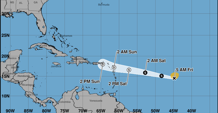
BASSETERRE — Tropical Storm Dolly officially formed Thursday and is racing westward toward the Leeward Islands, though forecasters expect it to weaken into a tropical wave before reaching the region this weekend, according to the National Hurricane Center’s 5 a.m. advisory.
As of 5 a.m. Friday, Dolly was centered about 1,145 miles east of the Leeward Islands, moving west near 24 mph with maximum sustained winds of 40 mph. The storm’s rapid forward speed is expected to continue over the next couple of days, putting the system, or what remains of it, near the Leeward Islands by this weekend.
No coastal watches or warnings are currently in effect, but the NHC is urging residents across the Leeward Islands, including St. Kitts and Nevis, to monitor Dolly’s progress. Forecasters said little change in strength is expected before Dolly degenerates into a tropical wave ahead of its arrival in the region.
Despite the anticipated weakening, the storm’s moisture is still expected to bring heavy rain. The NHC said the Leeward Islands could see heavy rainfall late Saturday into Sunday, with the wet weather then pushing toward the Virgin Islands, Puerto Rico and Hispaniola on Sunday and Monday. Forecasters warned that the rain could lead to flash flooding in areas of higher terrain across the Leeward Islands.
Tropical-storm-force winds currently extend up to 115 miles from Dolly’s center, and the storm’s minimum central pressure was measured at 1007 millibars.
The NHC said it will continue to provide updates as Dolly approaches the region, and residents are advised to stay alert for further guidance, particularly regarding the flood risk in higher terrain.