Caribbean System Weakens, New Wave Emerges
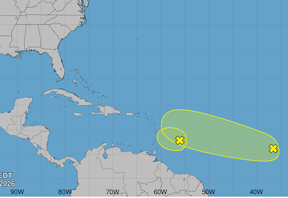
BASSETERRE — The tropical disturbance that has been approaching the Eastern Caribbean this week is now unlikely to strengthen further, the National Hurricane Center said late Friday, even as forecasters turn their attention to a second tropical wave farther out in the Atlantic that could develop in the days ahead.
In its overnight tropical weather discussion, the Miami-based center said the system, designated Invest AL92 and previously flagged locally as Invest 92L, is moving into an area of increasing upper-level winds and dry air, sharply reducing its already low chances of becoming a tropical depression or storm. Forecasters described further development as highly unlikely both in the next two days and over the coming week.
Despite the lower development odds, the center said strong, gusty winds and areas of heavy rain remain possible across portions of the Lesser Antilles on Friday night and into Saturday as the system passes through the region.
Meanwhile, forecasters are watching a separate tropical wave farther east in the central Atlantic, designated Invest AL94, which has a low chance of development over the next 48 hours but a medium chance over the next seven days. The center said that system could also run into strong upper-level winds early next week, which would lower its chances of strengthening as well. A third tropical wave in the Caribbean, near 78 degrees west, was not showing significant shower activity as of Friday evening.
Separately, the National Hurricane Center issued a gale warning for parts of the south-central Caribbean, including waters off Colombia and the Gulf of Venezuela, where a tightening pressure gradient between a high-pressure system near Bermuda and a low-pressure system over Colombia is expected to produce gale-force winds and seas up to 15 feet overnight and into Saturday morning. That warning does not extend to the waters around St. Kitts and Nevis.
There remains no tropical storm watch or warning in effect for St. Kitts and Nevis. Local officials have continued to urge residents to monitor conditions this weekend, particularly the chance of gusty winds and heavy showers, even as the immediate threat of a named storm has diminished.